|
) Mahi Mahi Mahi Mahi |
) anchorage anchorage |
) fishing boat wreck fishing boat wreck |
Y Not Report
Beveridge Reef
english
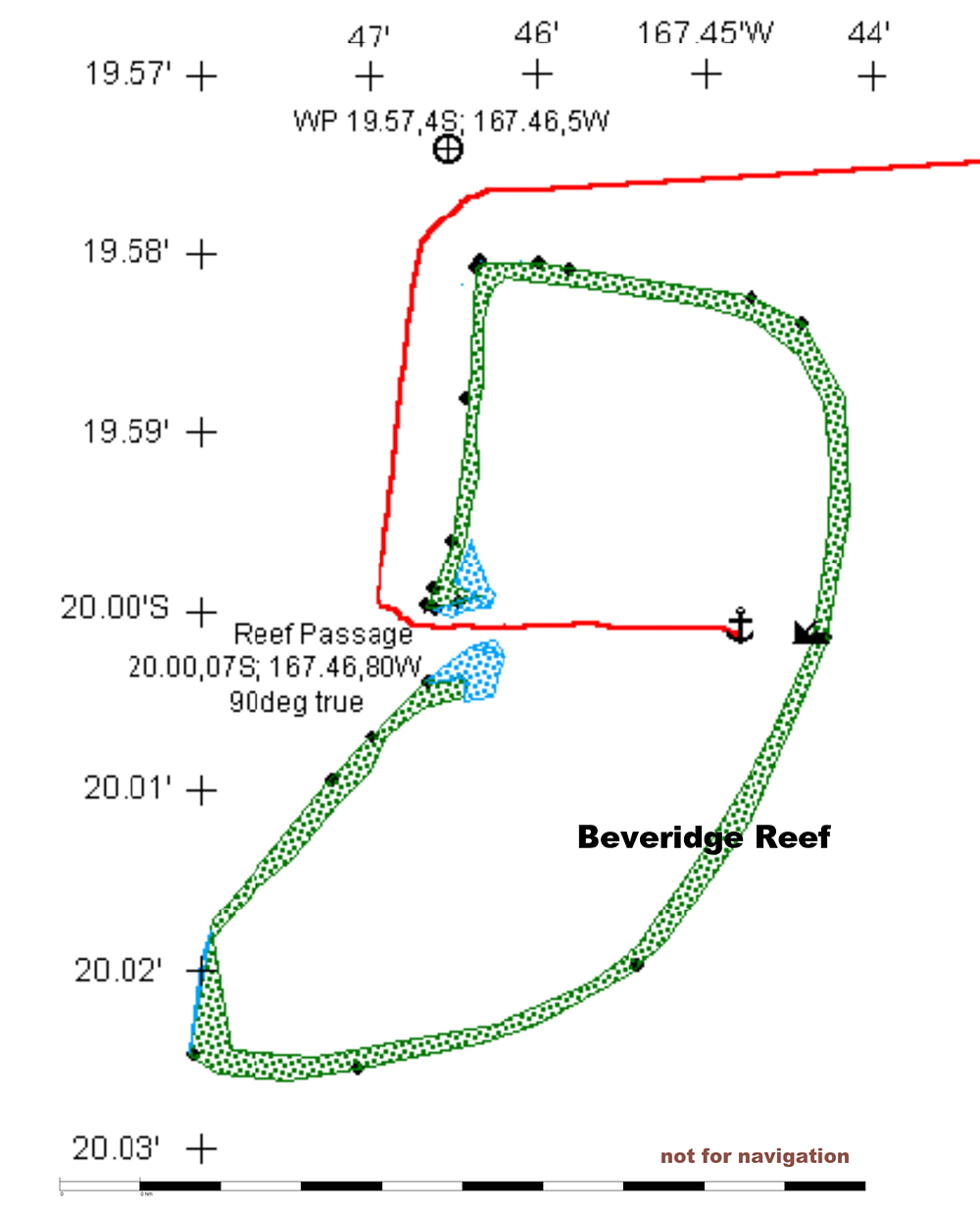
For everybody who wants to stay a few hours or days in Beveridge Reef we have drawn the chart below, which can be downloaded as png-file.
The radar reflection of the breakers on the edges of the reef in combination with the present GPS-Position were taken as the base for the scheme. The accuracy is accordingly.
Soundings were only done on the given track. In a distance of 0.5Nm from the reef edge the depth was not measurable, which means more than 500ft. The only exception is the North-West corner where we sounded minimum 120ft.
The waypoint NW of the reef is about 1Nm off the rim. You can head for either coming from Aitutaki or from Rarotonga.
The pass into the lagoon is at 20˚00,07’S and 167˚46,80'W. The coordinates were checked and approved by several Yachtsmen. The pass is about 120m wide. In the passage we sounded min. 27ft. If you follow this Latitude on 90˚ true the passage should not be a problem. A good indication for the bearing is the wreck of a fishing boat on the east side of the lagoon. It is still advisable to pass the entrance in good light conditions. The current we met was about 2,5kn at 2/3 of outgoing water at spring tide.
As far as we explored the lagoon the depth is almost everywhere between 30ft and 40ft. Spreaded coral heads in the flat sand bottom seem to be all deep enough to cross. You anchor where ever you want.
deutsch
Für alle, die vorhaben hier ein paar Stunden oder Tage im Beveridge Reef zu verbringen, haben wir eine Skizze des Riffs gezeichnet, die als png-File kopiert werden kann.
Die Skizze wurde nach Radarbildern angefertigt, die die Reflexion der Brandung am Riff erzeugt. Entsprechend ist die Genauigkeit einzuschätzen.
Lotungen für die Tiefenangabe wurden nur auf der eingetragenen Fahrtstrecke durchgeführt. Im Abstand von einer halben Seemeile vom Riff, war die Tiefe für uns nicht mehr messbar, d.h. größer als 150m. Ausnahme ist die Nord-West-Ecke des Riffs, wo wir min. 40m angetroffen haben.
Der Wegepunkt im NW des Riffs ist gut eine Seemeile vom Riff entfernt und kann sowohl von Rarotonga oder von Aitutaki kommend angelegt werden.
Der Pass liegt auf 20˚00,07’S und 167˚46,80'W. Die Koordinaten wurde von mehreren Yachten geprüft und bestätigt. Der Pass ist ca 120m breit. Wir haben in der Durchfahrt min. 8,5m Tiefe gemessen. Folgt man der Breite in rechtweisend 90˚ sollte die Durchfahrt kein Problem sein. Ein guter Richtungsweiser ist das Wrack eines Fischerbootes auf der Ost-Seite der Lagune. Dennoch ist es ratsam den Pass bei ausreichender Sicht zu befahren. Wir haben bei 2/3 ablaufendem Wasser während Springtide 2,5kn Strömung festgestellt.
Soweit wir es erkunden konnten beträgt die Wassertiefe in der ganzen Lagune zwischen 10-13m. Auf dem flachen Sandgrund befinden sich vereinzelt Korallenköpfe, die aber tief genug liegen. Man ankert wo immer man will.